


Ah, our beloved Connection One, land of Our Oasis and home of Sandffee. But how much else do you really know about the building complex and history of the greater Bukit Merah area in general?
Connection One
Formerly known as the Housing & Development Board (HDB) Centre at Bukit Merah, Connection One was built in 1987 to house HDB's main operations. It was subsequently renamed after HDB moved its headquarters to Toa Payoh in 2003. Today, SingHealth occupies about 32% of the lettable space across the two towers and three podiums, and is the largest tenant within the complex – go us!

Connection One today
(Credit: Yours truly!)
In 2011, HDB embarked on an energy conservation programme for the complex. A series of energy conservation measures were implemented, including using energy-saving LED lights in common areas, car parks and signage. Lifts were also retrofitted to be more energy-efficient with sleep mode functions, and priority lots were set aside for vehicles that run on compressed natural gas (CNG), or are hybrid or electric.
In recognition of this commitment to achieving a sustainable, energy-efficient environment in the complex, HDB received NEA's Best Energy Efficiency Practices in the Public Sector (Large Building) Award in 2013, and BCA's Green Mark Platinum Award in 2014 – the highest award for sustainable building design in Singapore!
Those of us who work in the complex are also no strangers to the variety of food we are a stone's throw from. Right in the lobby of Tower 1, we already have 4 eateries to choose from – Hom Thai, Sandffee, the Baking Industry Training College (BITC) eatery and Han's – not to mention the many more options we have in the greater Bukit Merah Central area.
Speaking of which…
Bukit Merah
Bukit Merah translates to "Red Hill" in Malay, and is a reference to the red, iron-oxide rich soils, known as lateritic soils, originally found around the area. But did you know that there is an old tale that tells how the soil got its reddish hue?
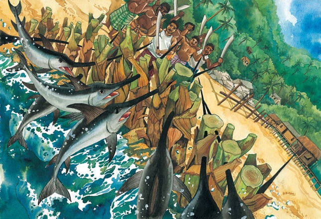
According to local legend, swordfish used to attack the villagers living in the coastal regions, near the present location of Tanjong Pagar. A young boy named Hang Nadim proposed a solution – to build a wall of banana stems along the coast, so that when the swordfish jumped out of the water to attack, their long, pointed bills would get lodged, rendering them defenceless. The villagers could then jump into the water and slaughter them, preventing future attacks.
This proved to be an ingenious idea and solved the swordfish problem, earning Hang Nadim great respect from the people, but also jealousy from the rulers. The Raja (or king) at the time, Paduka Seri Maharaja, ordered Hang Nadim's execution, and it is said that his blood soaked the soil of the hill where he was killed, giving rise to the red colouration of the soils.

An artist's impression of the swordfish getting lodged in the wall of banana stems
(Credit: National Heritage Board)
Today, Bukit Merah is home to eleven districts, including our beloved Bukit Merah Central, Singapore General Hospital, Tiong Bahru and HarbourFront. It also the most populated planning area in the Central Region and tenth most populated planning area in the country, being home to an estimated 150,000 residents.

Bukit Merah Town Centre in the 1980s
(Credit: remembersingapore.org)
Aside from the Bukit Merah Central area that we already know so well, how about a quick history lesson on a couple of our neighbours that we frequent often on our lunch breaks?
Tiong Bahru
In 1927, the Singapore Improvement Trust (SIT), an organisation set up by the British colonial government to deal with overcrowding and housing needs, acquired 70 acres of land as a pilot for public housing. This land was given the name Tiong Bahru, which means 'new cemetery' – tiong means 'cemetery' in Hokkien, and bahru means 'new' in Malay. As its name suggests, the area at the time was dotted with, well, cemeteries! It was hilly, swampy and largely occupied by squatters. By 1936, after extensive construction efforts, the first block of SIT flats were ready and partially occupied.

SIT flats in Tiong Bahru in the 1950s
(Credit: National Museum of Singapore, National Heritage Board)
A few years later when Great Britain declared war on Nazi Germany in 1939, plans were drawn to convert some motor garages at the flats in Seng Poh Road into bomb and air raid shelters, and flats were painted in camouflage colours.

The Tiong Bahru air raid shelter, used during the Japanese occupation. It is believed to be the last civilian air raid shelter on the island.
(Credit: Jerry Wong via flickr)
Now labeled the "the hippest part of town" by the Singapore Tourism Board, Tiong Bahru is known for its hipster art galleries, quirky bookstores and old-school architecture. Dotted also with hip cafés, insta-worthy street art and old-time eateries, the charming area is a melting pot of old and new, quirky and traditional.
HarbourFront
Originally known as Seah Im, HarbourFront was once near the southernmost point of our main island, until land was reclaimed in Tanjong Pagar and Tuas. The waters of Keppel Harbour, the stretch of water between the mainland and the southern islands of Pulau Brani and Sentosa, were (and still are!) naturally sheltered and deep, allowing the area to thrive as a transshipment port. The Singapore Cruise Centre was also opened in 1991 and was the country's very first international cruise terminal. Seah Im was later renamed HarbourFront in the 2000s to give the area a more atas vibe.

Keppel Harbour in 1960
(Credit: Keppel Offshore & Marine)
Today, HarbourFront is home to a host of shopping centres and office buildings, including VivoCity – Singapore's largest shopping mall! It is also the gateway to sunny Sentosa, with attractions such as our beaches, Resorts World Sentosa, Universal Studios Singapore and Adventure Cove.
Bukit Merah – 5 Other Quick Facts!
- The foundation for the Singapore General Hospital's first building was laid in 1821.
- All of the streets in Tiong Bahru are named after 19th and early 20th century Chinese pioneers.
- Labrador Nature Park was used as a defence outpost in the 19th century, until World War II.
- Gambier and pepper plantations were commonly found in the area from the 1850s to 1880s.
- The area is home to five (soon to be eight!) MRT stations, two bus interchanges, sixteen schools, 26 places of worship, seven shopping centres and nine parks.
Have some fond memories of Bukit Merah, or curious about the histories of other districts in the area? Let us know at joyatwork@singhealth.com.sg!
Stay Healthy the Easy Way
Get trusted health advice, offers and more.

Get the Health Buddy App
 Get it on Google Play